


chavaroche

bouscaillou
User
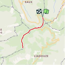

Length
10.5 km

Max alt
1729 m

Uphill gradient
516 m
Km-Effort
17.4 km

Min alt
1512 m

Downhill gradient
513 m
Boucle
Yes
Creation date :
2019-07-18 07:34:56.684
Updated on :
2019-08-03 10:46:10.696
5h00
Difficulty : Medium

FREE GPS app for hiking
 SityTrail
IGN / Geographical institutes
SityTrail Plus
The world is yours!
About
Trail Walking of 10.5 km to be discovered at Auvergne-Rhône-Alpes, Cantal, Le Falgoux. This trail is proposed by bouscaillou.
Positioning
Country:
France
Region :
Auvergne-Rhône-Alpes
Department/Province :
Cantal
Municipality :
Le Falgoux
Location:
Unknown
Start:(Dec)
Start:(UTM)
474121 ; 4995760 (31T) N.
Comments